|
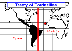
In principle the treaty followed the papal bull issued in 1493 by Pope Alexander VI, which fixed the demarcation line along a circle passing 100 leagues W of the Cape Verde Islands and through the two poles. Settlement east of the treaty line expanded to encompass the modern-day Portuguese-speaking country of Brazil. The official language of many countries west of the line is Spanish. Treaty of Tordesillas Between Spain and Portugal 1494 Prior to Columbus, Portugal had been the country most involved in exploration. Portugal had been sending expeditions for several decades, on missions to explore the African coast and seek out a sea-route to the Indies. As a result, Portugal was the dominant maritime power in the Atlantic. However, with Columbus' voyage westwards claiming the New World on behalf of Spain, an agreement was needed between the two countries to determine who had rights to which territories. Spain wanted to secure its claims to the New World, while Portugal wanted to protect its efforts to exploring a route around Africa to Asia.
Spain and Portugal were the two major Catholic powers of the time, and the prospect of a dispute between them was of great concern to Church authorities. Pope Alexander IV reacted quickly, issuing a decree on May 4, 1493 which established a boundary line running north to south through the mid-Atlantic, 100 leagues (about 320 mi. or 480 km) from the Cape Verde islands. Spain was granted possession of the unclaimed territories west of the line (ie. the New World), while Portugal was granted possession of unclaimed territories east of the line (ie. Africa and Asia). However, following Portuguese dissatisfaction with this arrangement, the line was shifted to 370 leagues (1,180 mi., 1,770 km) west of the Cape Verde islands before the agreement was formally ratified by both nations at a signing in the town of Tordesillas (Spain) in June 1494. At the time that the treaty was negotiated, only a very small area of the New World had actually been explored. Because no-one had yet sailed along the coastline of South America, no-one realized that a portion of South America stuck out past the boundary line and into the Portuguese zone giving Portugal a foothold in the western tip of Brazil. Unfortunately, the exact position of the boundary line was unclear. Was the 370 leagues to be measured from the eastern side of the Cape Verde islands, or the western side (a difference of 60 leagues, 193 mi., 290 km). Alternatively, the starting point might not have been the Cape Verde islands, but instead could have referred to Capo Verde on Africa's western coast. To complicate matters even more, a measurement of a league differed in different countries Portuguese leagues were different from Spanish leagues, and were different again from English or French leagues. Portuguese légua de maritima (maritime leagues) were only half as long as légua de sesmaria (land leagues), and the measures changed yet again depending on whether you were using Old Portuguese leagues or New Portuguese leagues. As a result, no-one really knew where the boundary line was. As the Portuguese presence in Brazil increased, the boundary line defined by the Treaty was generally ignored by Portuguese explorers and settlers, who eventually extended Portuguese territory to include all of modern-day Brazil (almost half of the South American continent). |
All rights reserved. For details and contact information: See License Agreement, Copyright Notice. |